Overview |
 Comments (0) |
 Ratings (0) |
 Download |

|
||||||||||||||||||
|
Search
Software
Advertisements!
Free-downloads
|
Options for Tiles2kml Pro
Advertisement
Tiles2kml Pro
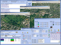
 T2K Pro integrates the rich world of GIS datasets and transfers your Geographic information data into Google earth. T2K Pro can handle rich data types and access large volumes of geographic data stored in files and databases, T2K can handle raster (imagery), Vector Map data and GPS Tracks/ Waypoints/ Routes. Tiles2kml Pro v2.31 provides a complete suite of conversion tools to easily visualize and convert your existing geospatial data. Tiles2kml Pro converts your raster imagery into very small tiles with different levels of detail allowing very quick view for very large datasets without loosing the image quality. Tiles2kml generates very small image tiles that can be served locally on your PC or your intranet. You can even share your imagery through the internet using the customized kml files that link Google Earth client to the small tiles on your webserver. So sharing your large imagery over the internet becomes a very quick and easy process. T2K Pro performs Raster data translation for the most popular raster formats. T2K Pro Free GIS Translator allows you to easily re-project, Crop and tile your raster data in single and batch modes. T2K Pro uses "On-the-fly" map re-projection to convert your Projected GIS Data into "Geodetic Lat/Lon - WGS 84" Coordinate system in order to be viewed in Google Earth. T2K Pro supports over 3000 pre-defined coordinate systems, and uses EPSG (European Petroleum Survey Group) and WKT (well-known text). Vector geographic features such as points, lines, and polygons can be easily converted to the most popular vector formats available: ESRI (SHP), MapInfo (TAB, MIF), Geography Markup Language (GML), and Keyhole Markup Language (KML). T2K Pro can convert popular vector formats into (Keyhole Markup Language -KML) files. Queries can be made to extract certain features from the vector Data and assign different kml 2.1 styles to them. Vector Map files in different coordinate systems are translated into "Geodetic Lat/Lon - WGS 84".
Advertisement
|
|||||||||||||||||