Overview |
 Comments (0) |
 Ratings (0) |
 Download |

|
||||||||||||||||||||
|
Search
Software
Advertisements!
Free-downloads
|
Options for Geodaten German Topo
Advertisement
Geodaten German Topo
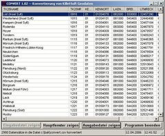
 A volume of data with map names, map numbers, corner coordinates and completing data of all official topographic maps of the Federal Republic of Germany. TK25: Data base table with data of the maps on a scale 1:25000. TK50: Table with data of the maps on a scale 1:50000. TK100: Table with data of the maps on a scale 1:100000. TK200: Table with data of the maps on a scale 1:200000 (TKUe200, General map). First the data base tables are present in a standard file format (dBase, ASCII / OEM character set). They can be imported directly into MS-EXCEL, MS-ACCESS and in Borlands dBase. In addition the data base tables can be converted with the program CONVERT into other data formats with the necessary characteristics, selections and sort sequences. The program is downloadable from http://www.killetsoft.de/p_cona_e.htm. With the program for example you can convert the data into the SDF format (Simple Document Format) or into the CSV format (Comma Separated Value) or direct in MySQL. The download contains a test composition of all maps, which are part of a TK200 and the exact data description.
Advertisement
|
|||||||||||||||||||